|
| |||||
Maps
From Brooklyn Centre Wiki
Contents |
1883 Atlas

- This map shows property owners along Newburgh Street (modern day Denison Avenue) and along Pearl St. (modern day West 25th St.). This represents all of Original Lot 74 and the eastern half of Original Lot 65.
- Comments:
- Ebenezer Foster was still alive at this time (1883) and the family had not yet started development on what was to become West 13th St., West 14th St., and Redman Avenue.
- Grand Army Court, now known as Garden Avenue, did not yet extend completely to West 23rd Place.
- See the Property Developers page for more specific information.
Foster Developments

- The Foster Developments shown in the map at the right were originally all part of Ebenezer Foster's farm.
- Ebenezer began to develop the area in 1891 with the first sales made along Redman Avenue. Prior to that, however, around 1867 he sold or gave land to his two sons, George Foster and Leonard G. Foster. Leonard received the land on the east and west sides of West 15th St.. George received land on the west side of West 14th St. and the portion of Redman Avenue between West 14th and West 15th.
Petty and Baldwin Development
The first map shows the entire Petty and Baldwin tract which extended from Denison Avenue at the north to Big Creek at the south. The map shows the property as it existed prior to the Harvard-Denison Bridge, which lopped off the upper corners of lots PB01, PB02 and PB03. Note also that it looks like Hapgood St. (later to be known as West 16th) had been proposed to extend all the way down the bluff into the Big Creek valley. 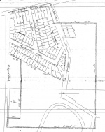
Petty and Baldwin tractThe second property map shows all the lot numbers and house outlines for the Petty and Baldwin Allotment which comprises West 14th St., Botany Avenue, and West 15th St. on the south side of Denison Avenue. Note how the bridge cut into several properties. 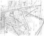
Petty and Baldwin allotment


Curtiss-Ambler Development
- The Curtis-Ambler development can be seen in the Petty and Baldwin map above.
- The land was originally part of Daniel Foster's farm and was sold to Curtiss Ambler in 1893 to partially settle Daniel's estate. The sale was handled by his nephew, George N. Foster.
