|
| |||||
Walking Tour
From Brooklyn Centre Wiki
Let's travel back in time and take a virtual "Walking Tour" of the Denison Avenue area.
Contents |
The Jennings tour
Starting point: The Harvard-Denison Bridge
- Just a few hundred feet from the western end of the bridge, we see a stairway leading down to Jennings Avenue. Descending to the street below, we now find ourselves in an industrial area with several factories visible, as well as railroad tracks crossing over Jennings. The tracks swing around the southern end of the bluff. Vegetation here is mostly scrub weeds, but if you follow the tracks back towards Big Creek, just about below Botany Avenue, you can pick blackberries and raspberries. The berry bushes are massive tangles and prickly to boot. Low to the ground, we see dewberries near the railroad tracks. There's milkweed here, too. The thrifty can be seen here picking up chunks of coal that have fallen off passing trains. Closer to the bluff the land is swampy and we've often been warned to watch out for quicksand. I'm not sure if that was just an old wives tale, or the truth, but water bubbles up in the stagnant ponds, so there is probably an active spring there saturating the sand.
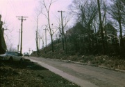
- Backtracking, we pass Red Hill[1] on our left. That isn't it's official name, of course. That would be West 14th St. where it descends down to Jennings in a serpentine fashion, hugging the side of the bluff. Older maps show it's name as Foster St., which is what it was named prior to the sweeping changes of 1906 for all North/South streets. Anyway, is it called "Red Hill" because of the berries that would inevitably fall out of overfilled buckets and end up smashed on the road surface? Or a mulberry tree alongside the road that drops it's berries at the end of it's growing season? Different generations probably had different names for the hill depending on what was most memorable about it for them. In even earlier times, this hill must have served as the "easier" route up to the top of the bluff and what was then called Newburgh Street. The hill is steep enough for cars to use -- how much more difficult it must have been for a wagon pulled by a horse or two on an unpaved muddy road.
- At the intersection of the tracks and the hill, we make the choice of following West 14th St. to where it crosses Jennings. It's dirty and muddy here because of the dust tracked over the road by trucks pulling in and out of the unpaved parking lot of Zeleznik's Tavern on the southwest corner. When it rains though, this little section of the street always seems totally water covered. Is there no sewer here?
- Just ahead, on the northeast corner, is Zuzek's Steak House. So what if they served ground horse meat? Those are the tastiest hamburgers you can buy in the city. Just east of Zuzek's is Harshaw Chemical; the neighborhood's smelliest resident business. No, wait! That distinction probably should go to the various fat rendering companies. You can hardly ever forget the experience of following one of their dripping trucks which were making their way from the slaughter houses on West 65th St. Those trucks left an odiferous trail that probably called every fly from miles around. Harshaw has left it's own mark -- only on the river. Has anyone ever seen a river that is bright orange? (See the article on Harshaw for an explanation.)
- Turning left on Jennings, we cross under the Harvard-Denison bridge. There are few businesses on the west side of Jennings, but the east side is brimming with them. The bridge supports are reflected in the stagnant pools of water that are formed by springs seeping out of this side of the bluff, too.
- As we near the Denison hill, to our left and facing the hill is a wooden multiple family dwelling. It's not exactly an apartment house -- more like what is known as a "flat". I'm not sure how many families live here. Probably at least four, and maybe as many as eight. The hill itself is really steep and paved with bricks. Could a horse and wagon have really made it up this hill? It goes straight up at a pretty severe angle.
- There is an almost constant little stream running along the curb. The result of yet another of those springs discharging from the bluff. These springs were important enough to the early settler, Ebenezer Foster, that he even reserved the rights to them in at least one deed when he sold off some of his property.
- On the north side of Denison hill is a grey, wooden stairway that extends from Jennings up to the top of the hill. Due to the steepness of the hill, the stairway is terraced in several sections so that you walk up about six steps then walk 6 feet on a flat section, then up another six steps, and then another flat section. Going up, it gives you a chance to catch your breath. Why put a stairway here? Well, many of the residents in the neighborhood above worked in the factories along Jennings, or on Belt Line Rd. and before they had cars, walking was the usual mode of getting around. In winter, the hill was an icy dangerous street. One winter, when the steps were covered over in snow drifts, I have to walk down the hill in the street. There were no sidewalks there. Slipping on the ice, I pretty much tobagganed on my butt right down and across Jennings. Thankfully, traffic was light and I managed to avoid a painfully squishing event. Had I not, we'd hardly be taking this walking tour today, now would we?
- Continuing north, just on the other side of the stairway, is another long multiple family dwelling. The lower section, facing Jennings, was once the site of Barski's Tavern. Next up is what looks like an abandoned store
Peeling Back the Years
- Let's imagine for a moment that we can peel away the years and see this area as it once existed.
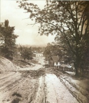
- Denison hill wasn't always paved in asphalt, nor even brick. There was a time when it was nothing more than a dirt road, probably no more than a wagon's width. There were probably deep ruts worn into the dirt by the wagon wheels. If we were to look east, to a time before the factories were to take over the valley, we'd see farmland and maybe a swamp or two. Across the river the hills would rise up unobstructed by a bridge or a steel mill. We might see the Austin Powder Company sitting to the east of the Ohio Canal. Looking a bit south of there, we'd probably be able to understand why Harvard Avenue crosses the Cuyahoga River where it does. The hills to either side of that area are much steeper. It is only at that crossing that the hill has a gentler slope. There was a covered bridge here at one time. No one ever mentions that or seems to be aware of it.
- Somewhere just north of Denison, Ebenezer Foster probably built his log cabin and thought to take advantage of the good source of water the river provided. At some point, he built an house on higher land at what would later become West 13th St. Maybe he liked the view, or maybe it was more convenient for taking his produce to market, or maybe the mosquitos became a major annoyance, or his cabin got flooded out once too many times by an overflowing river. It might even have been due to the railroad companies wanting to buy up parts of his land to lay tracks for trains to move through the valley towards downtown Cleveland.
The Redman tour
The Botany tour
The Ravine tour
NOTES
- ↑ Erna Baker, Reflections from Brooklyn Centre, (Oral interview of June 25, 1980 for the Brooklyn Centre Historical Society):Pages 134-135. "We called it the Red Road..the dirt was red..."; "We always called it Red Hill. And if I remember, it was steep and you got your shoes full of red dirt because it was loose."


